Noise and air pollution monitoring for more efficient mobility
Motivation

The city of Nice is facing challenges related to air and noise pollution in its central areas and busy thoroughfares. A significant number of employees work in concentrated hubs in the city center. For instance, a considerable number of workers commute to the city center from neighboring areas, with a majority (about 60%) relying on personal vehicles. The roads serving the city center are often congested, resulting in high levels of air and noise pollution. To improve the quality of life of its residents, the city of Nice aims to propose innovative mobility solutions through collection, homogenization and analysis of historical and real time data from different fields, leveraging the interoperability characteristics of such data. These solutions will include the suggestion of mobility alternatives such as car and bike sharing, enhancement and use of public transport offerings. By using Fiware’s standard data models, the city of Nice will leverage interoperability of data to deploy robust analysis of noise and air pollution, which can then be emulated by other territories.
The goal would be to improve the quality of life of its inhabitants by reducing this pollution linked in particular to road traffic, and this, by offering alternatives (alternative roads, improvement of the public transport offer or alternative solutions). The data model that would be produced could be replicable on the scale of other territories due to its quality and standardization. This model could become the "standard data format" for the analysis of these noise and air pollution.
Data Sets description

The Nice Côte d'Azur Metropolis has already implemented the FIWARE NGSI-v2 standard and has partnered with the Mediterranean Institute for Environmental Risk and Sustainable Development (Université Côte d'Azur - IMREDD) to develop a common data base called the “Territory Information Platform” (TIP). This data lake is already available through the Université Côte d'Azur - IMREDD website and will be improved and extended to NGSI-LD in the GreenMov project. To further improve the benefits from Smart Cities’ data, the consortium will deploy several services such as forecasting, recommendations and data analysis.
The Nice Côte d'Azur Metropolis has already implemented the FIWARE NGSI-v2 standard and has partnered with the Mediterranean Institute for Environmental Risk and Sustainable Development (Université Côte d'Azur - IMREDD) to develop a common data base called the “Territory Information Platform” (TIP). This data lake is already available through the Université Côte d'Azur - IMREDD website and will be improved and extended to NGSI-LD in the GreenMov project. To further improve the benefits from Smart Cities’ data, the consortium will deploy several services such as forecasting, recommendations and data analysis.
European Data Portal relevance
To develop and deploy standardized data models for the project, it is necessary to conduct a study on relevant data, including basic air and noise pollution data, and cross-referencing with road traffic data, potential sources of pollution, public transport options (routes, schedules, and stations), mobility alternatives (bike lanes, bike rentals, carpooling, etc.), and the characteristics of residents and commuters. The standardized data will be accessible and published on the European data portal.
Required mobility services

By analyzing noise and air quality data, transportation data, and traffic patterns, we can identify areas for improvement at the metropolitan level. This will aim at optimizing traffic routes and mobility offering in cities to minimize pollution and noise. Achieving interoperability is a key objective in our territorial ambitions, and the GreenMov project will help us accomplish it. Moreover, the methodology developed through this project can serve as a blueprint for other regions seeking to pursue a similar path.
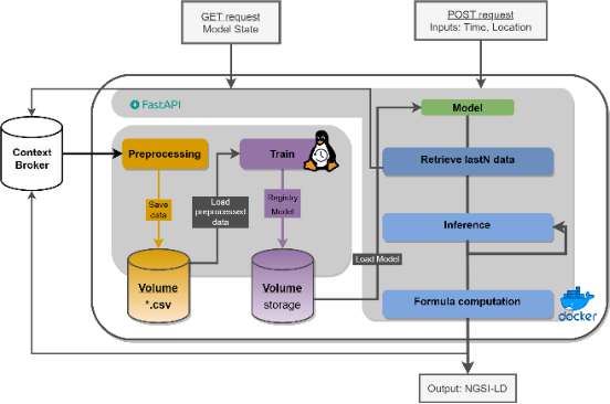
Historical Use of Context Broker
Prior to GreenMov project, the city of Nice has implemented a solution based on FIWARE NGSI v2 version. In the GreenMov project, the city will serve as a pilot for the NGSI-LD version of the Context Broker and will conduct comprehensive validation of the use of NGSI-LD for multi-services integration to support green mobility.